Tuna Radar
Temperature-based habitat context. Unconfirmed, not fish detection. Pick a region:
Tuna Radar: Clayoquot Sound & TofinoClick on map for GPS coordinates
Temperature-based potential habitat. Unconfirmed, not fish detection.
Tofino offshore · Seasonal context, not a fish-finding forecast or a safe-navigation plan.
Distance rings measured in nautical miles.
Tap the map or drag the red marker for approximate GPS coordinates and distance from the Tofino reference.
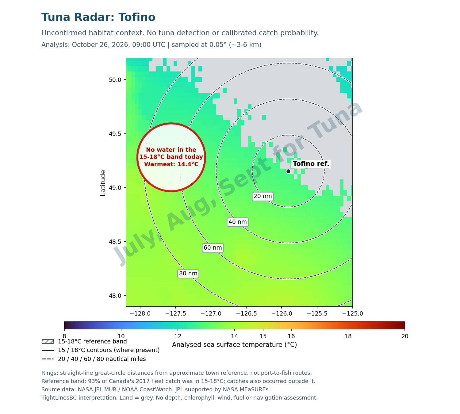
Satellite analysis sampled at ~3-6 km; no exact front or fish location.
Hatching = 15-18°C reference band. Black contours = 15/18°C where present. Dashed rings = 20/40/60/80 nautical miles from an approximate town reference, not boat routes.
NASA JPL MUR / NOAA CoastWatch; sampled at 0.05° (~3-6 km). Gap-filled satellite-derived analysis, not a live photo or a catch probability. These data were provided by JPL under support by NASA MEaSUREs program. Data & license ↗
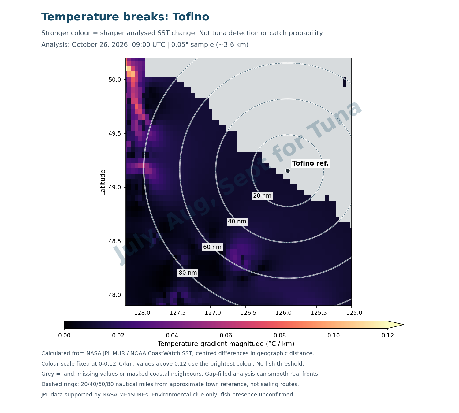
Satellite analysis sampled at ~3-6 km; no exact front or fish location.
Brighter colour = sharper analysed temperature change, not more fish. Daily gap-filled SST, sampled at 0.05° (~3-6 km). Grey includes land, missing values and masked coastal neighbours.
Colour scale is fixed at 0-0.12°C/km; brighter than the scale does not mean a proven tuna hotspot. JPL / NOAA data; supported by NASA MEaSUREs.
Unrated · 0 recent reports verified
No marker until at least 3 independent local catch reports from 2 sources are verified within 14 days. Unrated does not mean no fish.
How is this calculated?
Temperature map: satellite-derived NASA JPL MUR daily sea-surface temperature is sampled every 0.05° (~3-6 km). The hatched 15-18°C band is a research reference, not a fish detector.
Temperature breaks: for each ocean grid cell, compare the temperatures on either side east-west and north-south. Divide each difference by the distance between those neighbouring cells, correcting longitude distance for latitude. Combine the two rates as sqrt((east-west change)^2 + (north-south change)^2), in °C/km. A sharper colour means a stronger analysed temperature gradient. Land, missing neighbours and grid edges are masked, so a grey coastal patch does not always mean land. The colour scale is fixed at 0-0.12°C/km with higher values capped at the brightest colour for display only. There is no tuna-presence threshold or catch probability. Daily gap filling and coarse sampling can smooth, shift or miss fronts. This is an environmental clue, not the exact edge of a fish-holding front.
Distance rings: great-circle distances of 20/40/60/80 nautical miles from approximate town coordinates, not boat routes. A reported-distance card appears only for a verified source report less than 3 days old; older, future-dated or incompletely dated reports are omitted. It expires after 72 hours, independently of the map. Distance units stay as stated in the source.
Evidence and limits: 93% of Canada's 2017 fleet catch across all its fishing areas was in 15-18°C, but other research gives a broader 14-19°C niche. That does not mean a 93% chance of catching tuna. Catch-temperature evidence ↗ · Thermal niche ↗. NE Pacific research associates catches with SST fronts, but this simple gradient display is not that study's fitted catch model. Fronts study ↗
Action bar: actual local tuna catch reports within 14 days, counted once per boat/trip. Require 3 independent reports from 2 source outlets. Explicit Slow/Mixed/Good/Hot descriptions form a median category, not a probability. Promotions, forecasts and historical articles do not count. Insufficient evidence stays unrated.
Updates: visible all year. Each twice-daily site update checks for a new daily SST analysis and rebuilds both map layers when the analysis date changes. The real timestamp stays visible; data older than 3 days are labelled historical. A failed API check keeps the last real map with a warning. DFO rules and catch reports keep their own check dates. No automatic article scraping. These maps do not assess fish presence, clarity, depth, fuel, sea state, safe routes or legal access. Check marine forecasts and exact-area fishing rules before a trip.
Tuna Radar: Barkley Sound & Alberni InletClick on map for GPS coordinates
Temperature-based potential habitat. Unconfirmed, not fish detection.
Ucluelet offshore · Seasonal context, not a fish-finding forecast or a safe-navigation plan.
Distance rings measured in nautical miles.
Tap the map or drag the red marker for approximate GPS coordinates and distance from the Ucluelet reference.
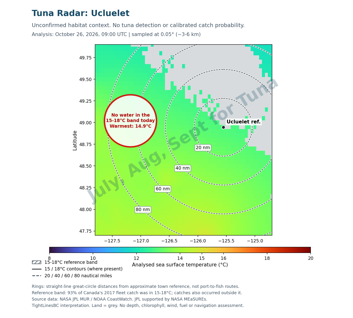
Satellite analysis sampled at ~3-6 km; no exact front or fish location.
Hatching = 15-18°C reference band. Black contours = 15/18°C where present. Dashed rings = 20/40/60/80 nautical miles from an approximate town reference, not boat routes.
NASA JPL MUR / NOAA CoastWatch; sampled at 0.05° (~3-6 km). Gap-filled satellite-derived analysis, not a live photo or a catch probability. These data were provided by JPL under support by NASA MEaSUREs program. Data & license ↗
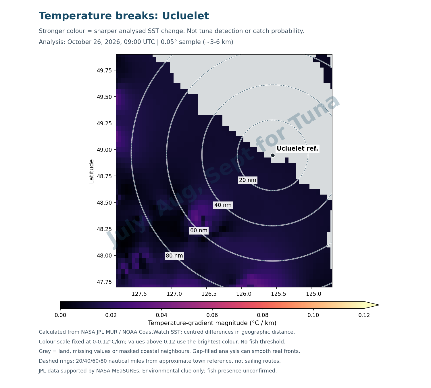
Satellite analysis sampled at ~3-6 km; no exact front or fish location.
Brighter colour = sharper analysed temperature change, not more fish. Daily gap-filled SST, sampled at 0.05° (~3-6 km). Grey includes land, missing values and masked coastal neighbours.
Colour scale is fixed at 0-0.12°C/km; brighter than the scale does not mean a proven tuna hotspot. JPL / NOAA data; supported by NASA MEaSUREs.
Unrated · 0 recent reports verified
No marker until at least 3 independent local catch reports from 2 sources are verified within 14 days. Unrated does not mean no fish.
How is this calculated?
Temperature map: satellite-derived NASA JPL MUR daily sea-surface temperature is sampled every 0.05° (~3-6 km). The hatched 15-18°C band is a research reference, not a fish detector.
Temperature breaks: for each ocean grid cell, compare the temperatures on either side east-west and north-south. Divide each difference by the distance between those neighbouring cells, correcting longitude distance for latitude. Combine the two rates as sqrt((east-west change)^2 + (north-south change)^2), in °C/km. A sharper colour means a stronger analysed temperature gradient. Land, missing neighbours and grid edges are masked, so a grey coastal patch does not always mean land. The colour scale is fixed at 0-0.12°C/km with higher values capped at the brightest colour for display only. There is no tuna-presence threshold or catch probability. Daily gap filling and coarse sampling can smooth, shift or miss fronts. This is an environmental clue, not the exact edge of a fish-holding front.
Distance rings: great-circle distances of 20/40/60/80 nautical miles from approximate town coordinates, not boat routes. A reported-distance card appears only for a verified source report less than 3 days old; older, future-dated or incompletely dated reports are omitted. It expires after 72 hours, independently of the map. Distance units stay as stated in the source.
Evidence and limits: 93% of Canada's 2017 fleet catch across all its fishing areas was in 15-18°C, but other research gives a broader 14-19°C niche. That does not mean a 93% chance of catching tuna. Catch-temperature evidence ↗ · Thermal niche ↗. NE Pacific research associates catches with SST fronts, but this simple gradient display is not that study's fitted catch model. Fronts study ↗
Action bar: actual local tuna catch reports within 14 days, counted once per boat/trip. Require 3 independent reports from 2 source outlets. Explicit Slow/Mixed/Good/Hot descriptions form a median category, not a probability. Promotions, forecasts and historical articles do not count. Insufficient evidence stays unrated.
Updates: visible all year. Each twice-daily site update checks for a new daily SST analysis and rebuilds both map layers when the analysis date changes. The real timestamp stays visible; data older than 3 days are labelled historical. A failed API check keeps the last real map with a warning. DFO rules and catch reports keep their own check dates. No automatic article scraping. These maps do not assess fish presence, clarity, depth, fuel, sea state, safe routes or legal access. Check marine forecasts and exact-area fishing rules before a trip.
Tuna Radar: Nootka Sound & Esperanza InletClick on map for GPS coordinates
Temperature-based potential habitat. Unconfirmed, not fish detection.
Esperanza offshore · Seasonal context, not a fish-finding forecast or a safe-navigation plan.
Distance rings measured in nautical miles.
Tap the map or drag the red marker for approximate GPS coordinates and distance from the Esperanza reference.
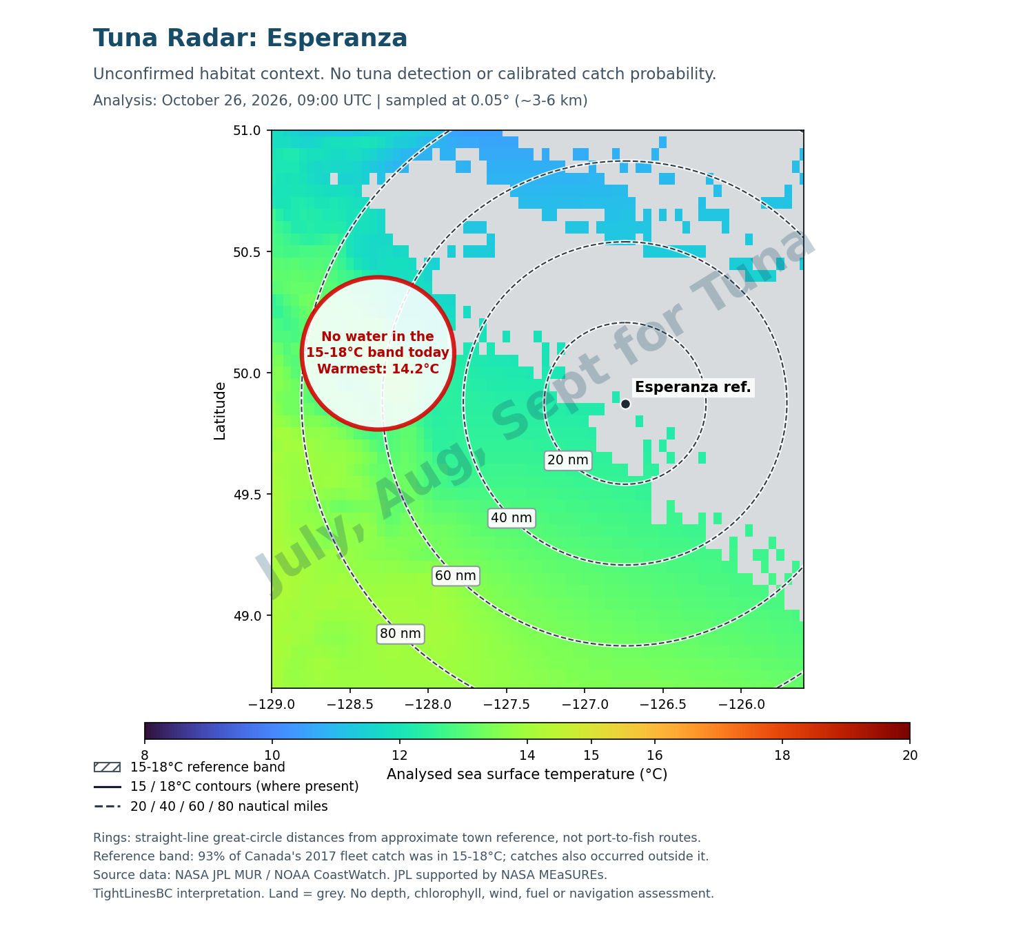
Satellite analysis sampled at ~3-6 km; no exact front or fish location.
Hatching = 15-18°C reference band. Black contours = 15/18°C where present. Dashed rings = 20/40/60/80 nautical miles from an approximate town reference, not boat routes.
NASA JPL MUR / NOAA CoastWatch; sampled at 0.05° (~3-6 km). Gap-filled satellite-derived analysis, not a live photo or a catch probability. These data were provided by JPL under support by NASA MEaSUREs program. Data & license ↗
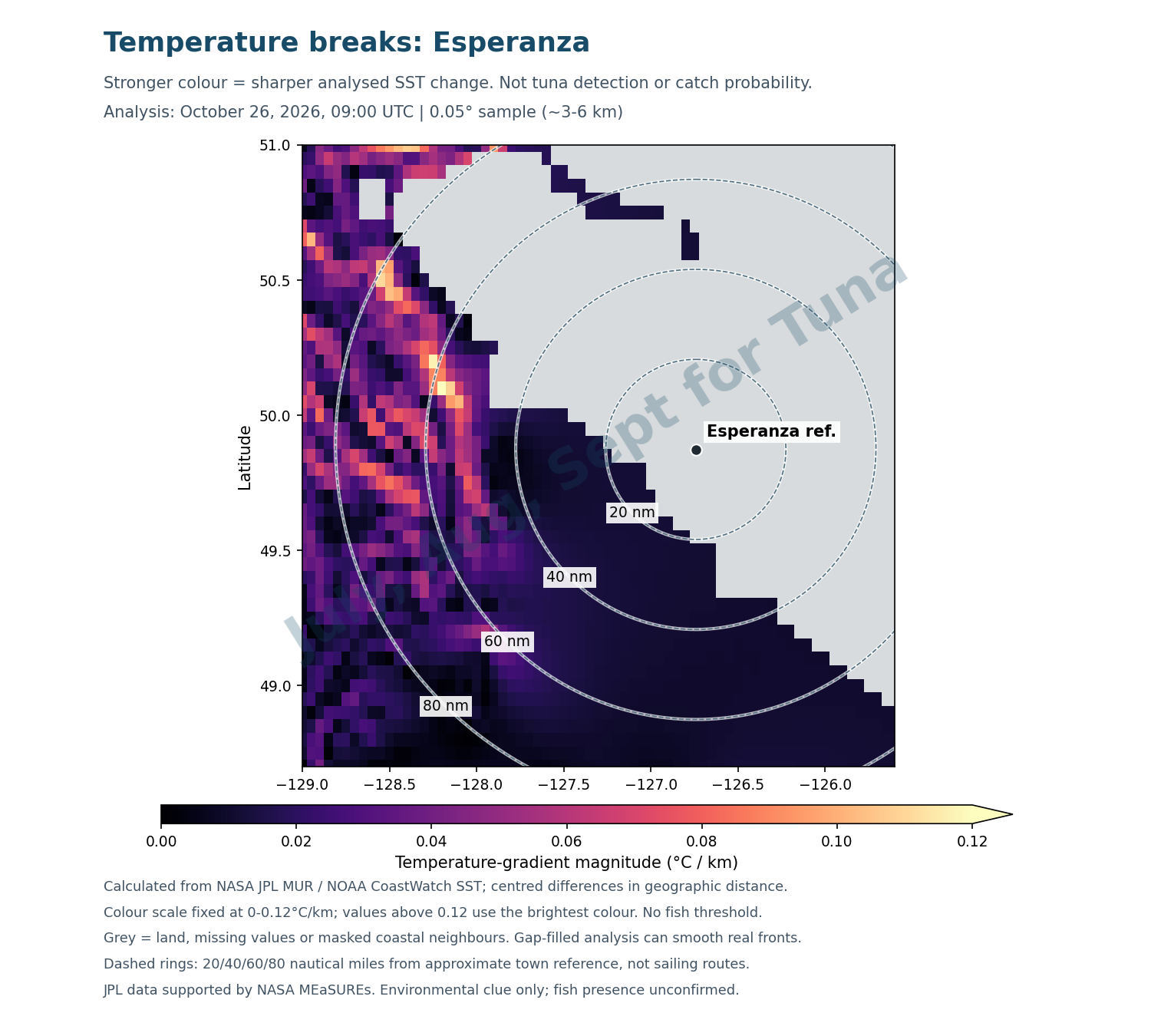
Satellite analysis sampled at ~3-6 km; no exact front or fish location.
Brighter colour = sharper analysed temperature change, not more fish. Daily gap-filled SST, sampled at 0.05° (~3-6 km). Grey includes land, missing values and masked coastal neighbours.
Colour scale is fixed at 0-0.12°C/km; brighter than the scale does not mean a proven tuna hotspot. JPL / NOAA data; supported by NASA MEaSUREs.
Unrated · 0 recent reports verified
No marker until at least 3 independent local catch reports from 2 sources are verified within 14 days. Unrated does not mean no fish.
How is this calculated?
Temperature map: satellite-derived NASA JPL MUR daily sea-surface temperature is sampled every 0.05° (~3-6 km). The hatched 15-18°C band is a research reference, not a fish detector.
Temperature breaks: for each ocean grid cell, compare the temperatures on either side east-west and north-south. Divide each difference by the distance between those neighbouring cells, correcting longitude distance for latitude. Combine the two rates as sqrt((east-west change)^2 + (north-south change)^2), in °C/km. A sharper colour means a stronger analysed temperature gradient. Land, missing neighbours and grid edges are masked, so a grey coastal patch does not always mean land. The colour scale is fixed at 0-0.12°C/km with higher values capped at the brightest colour for display only. There is no tuna-presence threshold or catch probability. Daily gap filling and coarse sampling can smooth, shift or miss fronts. This is an environmental clue, not the exact edge of a fish-holding front.
Distance rings: great-circle distances of 20/40/60/80 nautical miles from approximate town coordinates, not boat routes. A reported-distance card appears only for a verified source report less than 3 days old; older, future-dated or incompletely dated reports are omitted. It expires after 72 hours, independently of the map. Distance units stay as stated in the source.
Evidence and limits: 93% of Canada's 2017 fleet catch across all its fishing areas was in 15-18°C, but other research gives a broader 14-19°C niche. That does not mean a 93% chance of catching tuna. Catch-temperature evidence ↗ · Thermal niche ↗. NE Pacific research associates catches with SST fronts, but this simple gradient display is not that study's fitted catch model. Fronts study ↗
Action bar: actual local tuna catch reports within 14 days, counted once per boat/trip. Require 3 independent reports from 2 source outlets. Explicit Slow/Mixed/Good/Hot descriptions form a median category, not a probability. Promotions, forecasts and historical articles do not count. Insufficient evidence stays unrated.
Updates: visible all year. Each twice-daily site update checks for a new daily SST analysis and rebuilds both map layers when the analysis date changes. The real timestamp stays visible; data older than 3 days are labelled historical. A failed API check keeps the last real map with a warning. DFO rules and catch reports keep their own check dates. No automatic article scraping. These maps do not assess fish presence, clarity, depth, fuel, sea state, safe routes or legal access. Check marine forecasts and exact-area fishing rules before a trip.
How people find and catch Vancouver Island albacore
Summary in our own words of what published local guides say. It is not safety advice and not a promise of fish. Sources: Island Fisherman: "Chasing Tuna in Tofino"; Island Fisherman: "Getting Ready for Albacore Tuna Fishing in BC Waters"; Tofino Fish Guides, tuna page.
Safety first
- Both magazine articles say do not go offshore unless you and the boat are ready, and to learn from an experienced tuna guide on a first trip.
- Weather: the 2021 article says to stay inside if wind may reach 20 knots or more.
- Gear the articles name: a life raft, an EPIRB, a radio check with the Coast Guard before leaving, your MMSI programmed into the radio, and a float plan left with someone ashore.
- Go with other boats if you can, and keep a fuel reserve (the 2022 article suggests one third of a tank).
- Offshore boats: the 2022 article suggests a deep-V offshore hull and gives its own opinion on minimum boat size. Read it before you decide.
Finding the fish
- Blue water. Coastal water is green out to the edge of the canyons. Past the canyon edge it turns dark blue, and that is where the 2022 article says to start looking for tuna and other open-ocean fish.
- Warm water and wildlife. The same article looks for 16 to 18 C water, birds, dolphins and surfacing tuna. The 2021 article adds that many eyes and good binoculars matter more than electronics.
- Satellite maps. The 2021 article suggests a satellite imagery service, or NOAA's free data. Our radar uses NOAA and NASA data and is free.
- Distance. About 60 miles (100 km) off Tofino per Island Fisherman. Tofino Fish Guides reports 1:15 to 1:30 hours of running time to the blue water.
Gear and methods the articles describe
- Rods and reels. A medium-heavy to extra-heavy rod. For trolling, a 6 to 8 ft rod rated 30 to 80 lb with plenty of line capacity and smooth drag of 15 lb or more.
- Trolling. Cedar plugs, tuna feathers, Zukers and jet heads, at 5.5 to 6.5 knots as a starting point in the 2021 article, and 3 to 7 knots overall in the 2022 article. Darker colours in the morning and on overcast days, lighter as the sun comes up.
- Jigging. When you find a school, 5 to 7 oz jigs are described as a good fit, such as butterfly and needlefish jigs.
- Care of the catch. The 2021 article says to bleed tuna right away, give them a 10 to 20 minute cold saltwater bath and keep them on ice. Bring big coolers and secure them.
Rules: limits and licence
All fishers in B.C. tidal (salt) water need a valid B.C. Tidal Waters Sport Fishing licence (a salmon conservation stamp only if keeping salmon). Source: DFO recreational licence page.
| Area | Covers | Albacore (DFO, read Oct 27, 2026) | DFO page |
|---|---|---|---|
| Areas 23 / 123 | Bamfield, Port Alberni, Ucluelet | Open, daily limit 20, angling or spear fishing while diving | Areas 23 / 123 |
| Areas 24 / 124 | Tofino and Clayoquot Sound | Open, daily limit 20, angling or spear fishing while diving | Areas 24 / 124 |
| Areas 25 / 125 | Nootka Sound and Esperanza Inlet | Open, daily limit 20, angling or spear fishing while diving | Areas 25 / 125 |
DFO says the possession limit for most species is double the daily limit. DFO's tables also list Pacific bluefin and other tuna species for these areas, so read the full page. Limits, closures and notices change, so check the area page on the day you go. This is not a clearance for protected areas, marine closures or US waters. The pages above were last updated by DFO on October 20, 2026.
Frequently asked questions
When is albacore tuna season off Vancouver Island?
DFO lists albacore as open in the areas below as of October 27, 2026, but the fish are only within reach offshore in summer and early fall. Island Fisherman Magazine says schools arrive in July and anglers chase them until about October 1. Tofino Fish Guides offers tuna trips in August and September.
How far offshore do you have to go?
Island Fisherman puts the schools about 60 miles (100 km) off Tofino. Tofino Fish Guides says the run to the blue water is usually 1 hour 15 minutes to 1 hour 30 minutes in decent conditions. Distance changes day to day with where the warm water sits.
What water temperature are people looking for?
Island Fisherman's 2022 gear article says anglers look for blue water at about 16 to 18 C. Our radar shades a wider 15 to 18 C reference band, based on where most of Canada's 2017 fleet catch was reported, and fish are also caught outside it. It is a clue, not a fish finder.
Do I need a licence to fish for tuna?
Yes. DFO says anyone fishing for finfish in B.C. tidal waters needs a valid B.C. Tidal Waters Sport Fishing licence. A salmon conservation stamp is only needed if you keep salmon.
What is the daily limit for albacore?
DFO's tidal-area pages, read October 27, 2026, list albacore as open with a daily limit of 20 in Areas 23/123, 24/124 and 25/125. DFO says the possession limit for most species is double the daily limit. Check the area page before you go, because limits and closures change.
Does the radar show where the tuna are?
No. It shows satellite sea-surface temperature and where it changes fastest. Warm water and temperature breaks are one clue anglers use. It does not detect fish, and it is not a safety or navigation tool.
Is it safe to go offshore for tuna in a small boat?
Not without preparation. Island Fisherman's 2021 article says offshore weather can change fast, and both articles suggest a first trip with an experienced guide. See the safety points above. This page is not safety advice.
What do people use to catch albacore?
Island Fisherman describes trolling cedar plugs, tuna feathers, Zukers and jet heads at roughly 5.5 to 6.5 knots as a starting point, and jigging with 5 to 7 oz jigs when a school is found. See the gear section for details and sources.
Do your own weather and sea conditions research to confirm. This is not a recommendation to fish. The week-ahead score rates sea conditions and season only. It cannot see fish.
Sources
- Island Fisherman: "Chasing Tuna in Tofino", Island Fisherman Magazine, Sept 30, 2021. Sponsored content by Tofino Resort + Marina.
- Island Fisherman: "Getting Ready for Albacore Tuna Fishing in BC Waters", Island Fisherman Magazine, Aug 14, 2022.
- Tofino Fish Guides, tuna page, a charter operator's own page.
- DFO Pacific tuna plan summary.
- DFO tidal-area pages: Areas 23 / 123, Areas 24 / 124, Areas 25 / 125; DFO recreational licence page.
- Radar: NASA JPL MUR sea-surface temperature via NOAA CoastWatch. JPL data supported by NASA MEaSUREs.
Page built October 27, 2026. We have not paid for or been paid for any listing here. Not navigation or safety advice.